Hiking Guide
Great trails to stretch your legs and explore the neighborhood
Our Favorite Trails
Hartshorne Woods
Hartshorne Woods is conventionally located right in The Woodland House’s backyard. There is even a secret local entrance right down the block!
Top Trails:
Secret Entrance —> Cuesta Ridge —> Battery Loop
Depart The Woodland House and head west on Prospect St. until you reach the fork in the road. Head North up the Hill and once you reach the top you will see a small trail entrance maintained by Steven whom lives on the trail. Please be respectful of his property as he meticulously maintains the grounds. Follow the secret entrance until you hit Cuesta Ridge, make a left to head east towards the Battery. In about .75 miles you will be in the main Hartshorne Woods parking lot right next to Battery Lewis and the former Navesink Military Reservation. Once you reach the Battery you can do the Battery Loop making sure you stop at Black Fish Cove and Lower Rocky Point.
Secret Entrance —> Cuesta Ridge —> Grand Tour —> Portland Place
Portland Place is the last remaining home of the Hartshorne Family and a National Historic Landmark tucked in a quiet neighborhood on the Navesink River. You’ll follow directions to the Secret Entrance, head left on Cuesta Ridge, and make another left when you reach the trail towards the Command Loop. You’ll want to head through the concrete pillars down the gravel road towards Indian Terrace and Grand Tour Road. Head down Grand Tour by making a right once you exit the gravel road and walk until you hit Tan Vat Road. Portland Place will be on your left. It’s a stately white home on the Navesink.

Sandy Hook
Sandy Hook is about a mile walk from The Woodland House and is a 6 mile long barrier spit. If you are planning a hike from the house it’s recommended you bike or drive - unless you are planning a very long walking day!
Top Trails:
South Beah Dune Trail and the Old Dune Trail
Length: 1.9 mile, one-way, plus 1.6 mile return trip on the Multi-Use Path, unless you have a ride waiting at the end (add .6 mile for the South Beach detour)
Time: 2 hours with South Beach detour
Difficulty: Easy
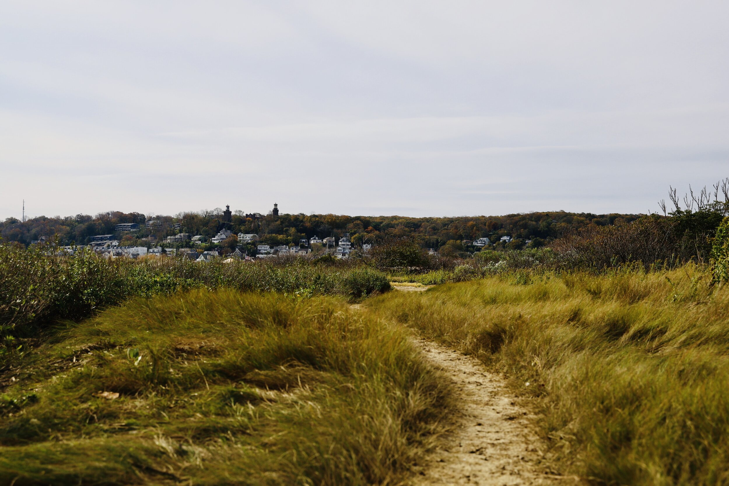
The two main hiking trails at the Sandy Hook Unit of Gateway National Recreation Area are the South Beach Dune Trail and the Old Dune Trail. The South Beach Dune Trail runs between Parking Lot L and the beach just north of the Nike Missile Launch Site. The Old Dune Trail runs between Parking Lot E and the beach just south of the missile site. You can connect the two together by walking along the beach. Neither offer anything particularly scenic or historically interesting, so hiking them is mainly for exercise purposes. If that’s your goal, might as well hike them both as one continuous trail.

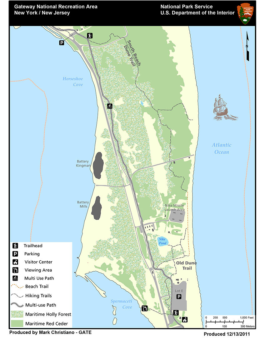
Fisherman’s Trail
Length: .6 mile one way to the bay and another .4 mile to the northern point of Sandy Hook
Time: 1 hour
Difficulty: Easy, but you are walking in deep sand the entire way
You don’t have to be a fisherman to enjoy a hike on the Fishermen’s Trail at the Sandy Hook Unit of Gateway National Recreation Area. It leads out to the bay at the northern end of the Sandy Hook peninsula, and just getting to the tip is a pretty neat experience for anyone. I saw two fishermen and two people walking along the beach, so including me, the non-fishermen outnumbered the fishermen. Just don’t hike the trail in search of a place to swim because there are no lifeguards and the current is very swift. There is also quite a lot of garbage on the beach, and I’m not talking about soda cans and cigarette butts left by bathers. This is industrial-type garbage that washes up from New York City. When I did the hike, there was even a wrecked boat half-buried in the sand, most likely tossed here by Hurricane Sandy in 2012.
The Fishermen’s Trail begins at the end of Parking Lot M. This is not a beach access lot, so there is no fee to park here. There is no sign that identifies the trail, so be sure not to confuse it with a dirt road to the left of the parking lot that heads south.
The trail starts off through a maritime forest on a hard-packed dirt trail, but in about a quarter mile the terrain opens up a little. You will pass Battery Peck shortly after departing, so if you don’t see it, you’ve gone the wrong way (the battery at the parking lot is the Nine-Gun Battery).
The trail forks soon after passing the battery. A right leads to an observation deck that was set up with bird watchers in mind. It’s just 75 yards down the trail, so it’s not a big detour if you want to check it out (the trail was closed when I visited). The Fisherman’s Trail continues straight ahead on deep beach sand and remains that way for the rest of the hike. When walking on beach sand you must take two steps just to move one step forward. While the terrain is as flat as a pancake, my legs got tired after a while.
It is .6 mile to the beach from the parking lot. For the first .4 mile you will be walking through a maritime forest, though this is not to say you will be in the shade. The trees in this forest aren’t very tall, and the trail itself is completely out in the open, so wear a hat and apply sunscreen if avoiding the sun is important to you. There are a few places where other trails branch off of it, but the Fishermen’s Trail is always the one that continues straight ahead.
After .4 mile the trail emerges from the forest and is completely out in the open sand. The bay is another .2 mile ahead, but if you want to reach the actual point of Sandy Hook, take a right at the water and walk along the shore for another .4 mile. Without some sort of GPS and satellite map it’s hard to know where you are in the overall scheme of things, but the way to tell when you are at the point is that the waves change from calm, bay-side waves to rougher, ocean waves.
It takes about an hour to walk out-and-back on the Fishermen’s Trail, though this does not count time spent on the beach relaxing or fishing. Seeing the tip of the peninsula is certainly a noteworthy experience. Of all the trails in the Sandy Hook Unit of Gateway National Recreation Area, this is the only one worth hiking.

Spermacetti Cove Boardwalk
Length: .25 mile, round trip
Time: 10 minutes
Difficulty: Easy
The Spermaceti Cove Boardwalk at the Sandy Hook Unit of Gateway National Recreation Area leads to an observation deck overlooking the marsh area of Spermaceti Cove. It is located between Parking Lots D and E, but on the other side of the road. You can walk to the overlook and back in about ten minutes, but if bird watching is your goal, you might stay in the marsh for a much longer time.